Toronto, Canada, October 19, 2016 -- Eloro Resources Ltd. (TSX-V: ELO; FSE: P2Q; "Eloro") is pleased to announce that it has completed the Phase I exploration program recommended in the recently filed National Instrument 43-101 Technical Report on the La Victoria Gold/Silver Property (the "Property") in Huandoval District, Pallasca Province, Ancash Department, Peru authored by Mr. Luc Pigeon, M.Sc., P.Geo. (see press release September 7, 2016). Phase I included geological mapping and sampling, geophysical surveys, data processing, permit applications, and accessibility improvements for the Phase II drill program. The Phase II diamond drilling, which will total up to 3,000m, will focus on targets at the San Markito and Rufina Mineralized Zones.
Tom Larsen, President and CEO of Eloro commented: "We expect the Phase II diamond drilling program to start late in Q4 of this year. Dr. Bill Pearson, P.Geo., Chief Technical Advisor for Eloro and I recently completed a site visit to the Property. Preparations are well advanced for the drill program which will commence once final permitting is received. Our newly appointed in-country General Manager, Luc Pigeon, P.Geo., has organized a strong team to support the exploration work based from Huandoval, a small town near the southwest end of the La Victoria claim group. Luc, who has more than ten years experience working in Peru, has worked closely with the local community in establishing this base and building good local support for our program."
Dr. Bill Pearson added: "Our initial program of geological mapping, sampling and geophysical (IP) surveys greatly increased our understanding of the potential of the Property and outlined a number of follow-up targets. In advance of the drilling, we are starting the second phase of our geological mapping and sampling program led by Dr. Osvaldo Arce. This work will concentrate on the 3-plus km potential strike length of the San Markito-Victoria silver-gold mineralized breccia zones which have had very limited previous exploration. The new road being constructed by the Peruvian government that opens up the north-eastern portion of the Victoria concession into the San Felipe II concession to the east (see Figure 1) will greatly facilitate this work. In addition, we will be completing a detailed soil geochemical survey of Rufina North to better define a potential heap-leachable gold target near a strong IP anomaly outlined in our survey."
Geology and Mineralization
The Property, which covers approximately 45 square kilometres (Figure 1) is located within a prolific epithermal gold deposit belt that spans from Cajamarca to Ancash and that includes such deposits as Yanacocha, Lagunas Norte, La Arena and Pierina. The La Arena and the Santa Rosa open pit mines are respectively located 50km and 25km northwest of the Property.
Gold-silver mineralization on the La Victoria property is spatially and structurally associated with a series of dioritic to granodioritic Victoria intrusives that intrude sandstone and shale of the Chicama Formation. The style of mineralization is typical of low sulphidation epithermal deposits. Figure 2 is an analytical signal magnetic map developed from reprocessing of 2011 data, which shows the widespread occurrence of interpreted intrusions and principal gold (Ag) + silver (Ag) showings and occurrences. Each potential intrusion is considered prospective, warranting followup work. The areas of the magnetic anomalies tend to be recessively weathered covered by Quaternary colluvium and alluvium suggesting that the intrusives are likely altered. The location of the new road being constructed in the northeastern part of the property which substantially improves access, is also shown.
Four principal mineralized zones have been identified on the Property: San Markito, Rufina, Victoria and Victoria South with the first two being the most advanced targets. Limited sampling to date has indicated the presence of high grade mineralization in each of these mineralized areas but more systematic sampling and diamond drilling is required to assess the potential of these targets.
At San Markito, the northwest-trending mineralized zone extends for at least 1300m along strike and is up to 400m wide with the bulk of mineralization located within silicified sedimentary rocks near the contact with intrusive rocks. Results from previous sampling returned significant values up to 2.27 g/t Au and 1814 g/t Ag with enriched values of Pb up to 16.82% and arsenic and antimony greater than 1% analytical limit. Initial planned drilling will focus on testing this mineralized zone along strike and vertically.
At Rufina five vein sets of 20m to 70m in width have been identified in the western part of the mineralized zone. Vein sets are composed of iron oxide-quartz-arsenopyrite veins, in veinlet swarms, stockworks, and breccia zones. They are well developed in intrusive rocks as well as underlying rocks of the Chicama Fm. Three surface samples from the mineralized zone averaged 8.8 g/t gold and 23.8 g/t silver, while one 50cm chip sample taken from an artisanal adit returned 15.1 g/t gold, 136.5 g/t silver, with 1.61% lead and 3.75% zinc. In the northern part of Rufina at higher elevations, the mineralized rocks are oxidized and have argillic alteration suggesting potential for heap-leachable gold mineralization. The recently completed IP survey shows that the high resistance diorite (the main mineralized lithology present on the Rufina zone) is concentrated near the surface in this area and is underlain by conductive and chargeable sedimentary rocks; this target, known as Rufina North, will be tested in the planned drill program.
Victoria and Victoria South are earlier stage targets but which have similar geological settings to San Markito and Rufina. Victoria is on the San Markito structure approximately 500m to the east. Samples there have returned values to 4.3 g/t Au and 927 g/t Ag. Copper concentrations are elevated in most samples with values reaching up to 4.29% Cu. Sampling at one showing at Victoria South returned 8.4 g/t Au over 1.2m.
For additional technical information on the La Victoria Project, the reader is referred to the NI 43-101 Technical Report on the La Victoria Au-Ag Property, Ancash, Peru filed under Eloro's profile on SEDAR (www.sedar.com).
About Eloro Resources Ltd.
Eloro is an exploration and mine development company which recently acquired a 100% undivided interest in the La Victoria property, located in the prolific North-Central Mineral Belt of Peru. The La Victoria Property covers 45 square kilometres and is within 50 kilometres of several large low-cost producing gold mines, with three producers visible from the Property. Infrastructure in the area is good with access to road, water and electricity and is located at an altitude that ranges from 3,100 m to 4,200 m above sea level. Eloro also holds a portfolio of gold and base-metal properties in northern and western Quebec.
For further information please contact Thomas Larsen, President and C.E.O. or Jorge Estepa, Vice-President of Eloro Resources Ltd. at (416) 868-9168
Information in this news release may contain forward-looking information. Statements containing forward-looking information express, as at the date of this news release, the Corporation's plans, estimates, forecasts, projections, expectations, or beliefs as to future events or results and are believed to be reasonable based on information currently available to the Corporation. There can be no assurance that forward-looking statements will prove to be accurate. Actual results and future events could differ materially from those anticipated in such statements. Readers should not place undue reliance on forward-looking information.
Neither the TSXV nor its Regulation Services Provider (as that term is defined in the policies of the TSXV) accepts responsibility for the adequacy or accuracy of this release.
Jim Steel MBA, P.Geo., a Qualified Person in the context of NI 43-101 has reviewed and approved the technical content of this news release.
FIGURE 1
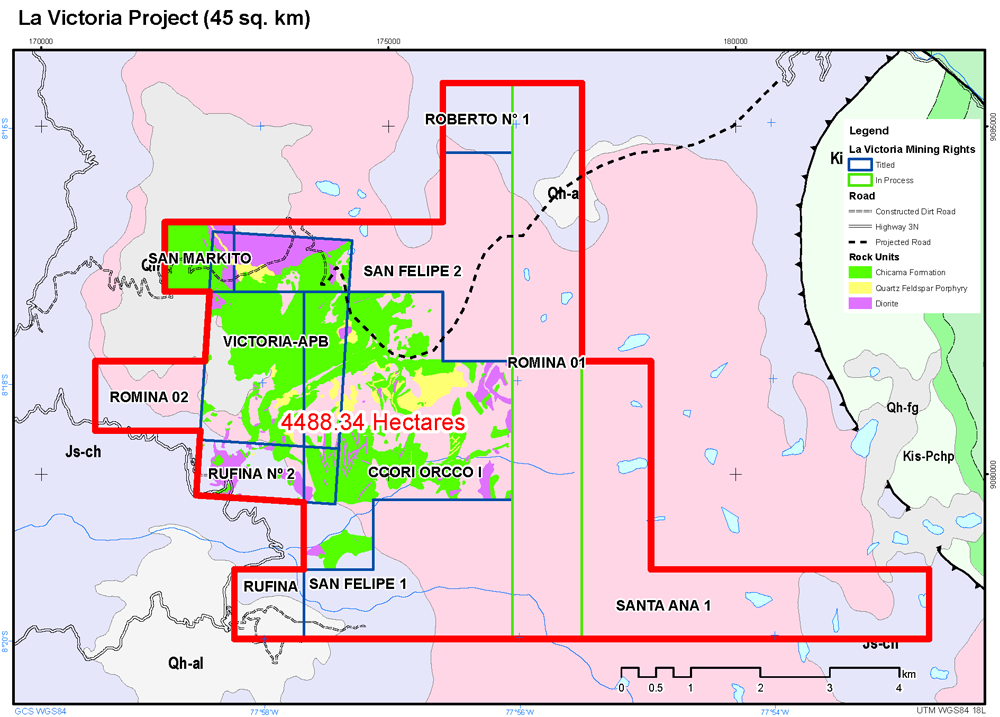
FIGURE 2
Magnetic Map Depicting Dioritic Instrusive Targets

October 19, 2016