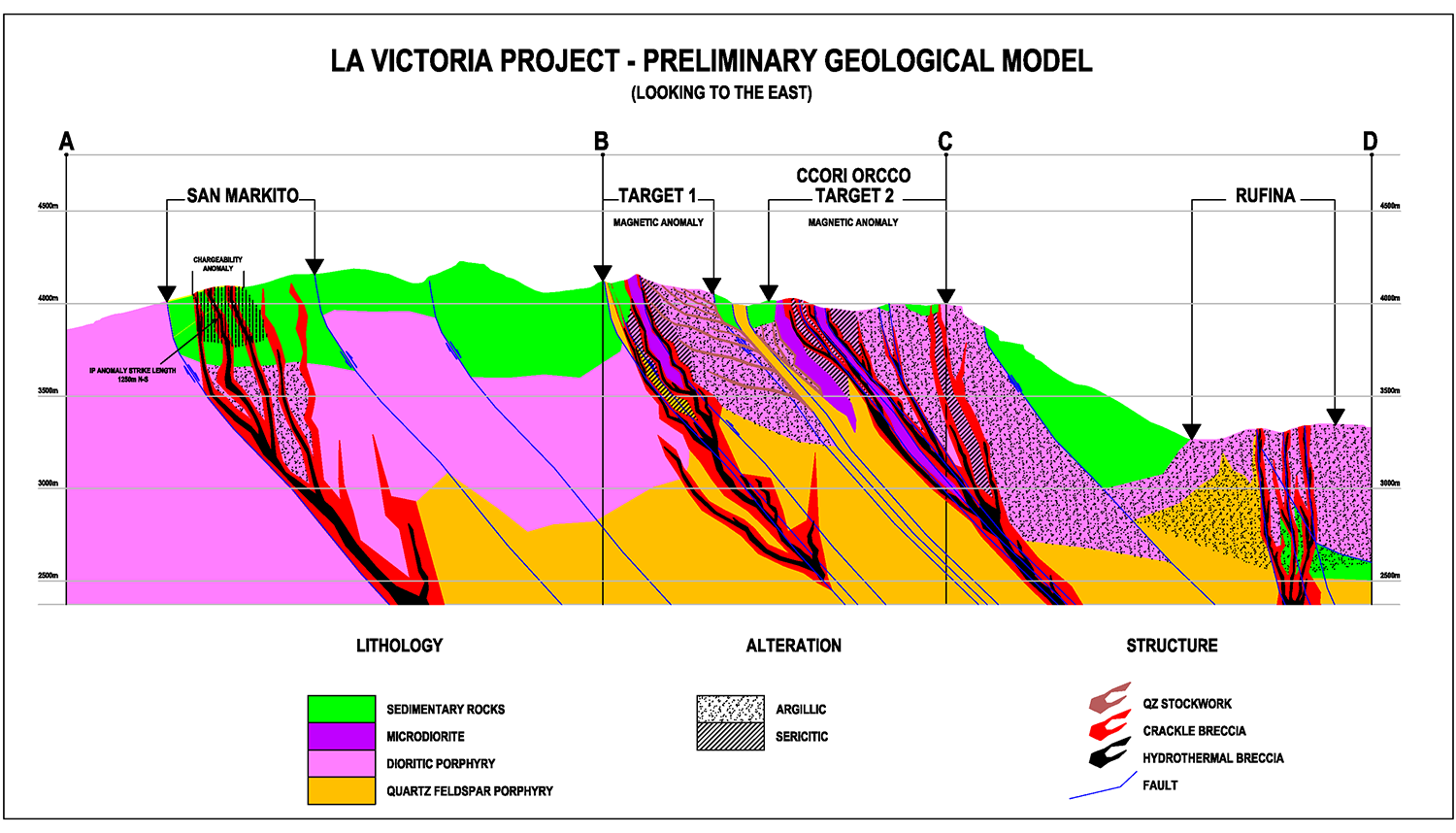
Toronto, Canada, April 25, 2017 -- Eloro Resources Ltd. (TSX-V: ELO; FSE: P2Q; "Eloro") is pleased to announce further results from its on-going geological mapping and sampling program at its La Victoria Gold/Silver Property (the "Property") in Huandoval District, Pallasca Province, Ancash Department, Peru. As shown in Figure 1, this work has outlined two major new target areas in the north-central part of the Property known as Ccori Orcco. Target 1 is located approximately 1.5km east of San Markito while Target 2 is approximately 500m south of Target 1 and 1.5km east of Rufina (Figure 1). Figure 2 is a composite cross section for the San Markito-Ccori Orcco-Rufina areas showing the potential extent of the epithermal systems.
Both target areas in Ccori Orcco are at least 200m wide and extend for approximately 1 km along strike parallel to major NW-SE and NE-SW structures in the area. Mineralization is associated with hydrothermal (argillic and silicic) and supergene alteration in hydrothermal breccias associated with quartz feldspar porphyries ("QFP"). Preliminary sampling has been carried out in the area; results are pending.
Reinterpretation of historical Induced Polarization ("IP") data in the San Markito area shows a strong chargeability anomaly that coincides with the Ag-Au showings in mineralized breccias (Figure 1). The anomaly extends for at least 1250m North-South at depths from about 50 m to more than 200m, the maximum depth reached with the array that was used for the survey. The anomaly extends as far south as the last IP line. It is thus open to the South as well as to greater depth. The shape of the anomaly suggests elongation in a north or north-northwest direction, parallel to important structures that have been mapped at San Markito.
Tom Larsen, President and CEO of Eloro commented: "We have now outlined five major target areas at La Victoria. Two of these areas, Rufina and San Markito, are nearing final permit approval for diamond drilling which is expected to commence in June. Extension of the IP surveys to cover the new target areas in Ccori Orcco is planned to commence at the end of May as well as continuation of the successful mapping and sampling program. Reconnaissance work including a detailed magnetic survey will also be carried out on the new southern claim block."
Dr. Bill Pearson, Chief Technical Advisor for Eloro, added: "It is evident that there are multiple low to intermediate sulphidation epithermal systems on the La Victoria project. These systems appear to be controlled by major NW-SE trending faults with mineralization typically occurring at intersections of these faults with NE-SW trending structures as well as along intrusive-sedimentary contacts. The identification of QFP intrusives in the Ccori Orcco area is very positive as these intrusives are associated with major gold deposits elsewhere in the belt."
About Eloro Resources Ltd.
Eloro is an exploration and mine development company which holds a 100% undivided interest in the La Victoria Gold/Silver Project, located in the prolific North-Central Mineral Belt of Peru. The La Victoria Gold/Silver Project covers 80.4 square kilometres and is within 50 km of several large, low-cost producing gold mines, with three producers visible from the property. Infrastructure in the area is good with access to road, water, and electricity and is located at an altitude that ranges from 3,100m to 4,200m above sea level. Eloro also holds a portfolio of gold and base-metal properties in northern and western Quebec. For additional technical information on the La Victoria Project, the reader is referred to the NI 43-101 Technical Report on the La Victoria Au-Ag Property, Ancash, Peru filed under the Company's profile on SEDAR (www.sedar.com).
For further information please contact Jorge Estepa, Vice-President of Eloro Resources Ltd. at (416) 868-9168
Information in this news release may contain forward-looking information. Statements containing forward-looking information express, as at the date of this news release, the Corporation's plans, estimates, forecasts, projections, expectations, or beliefs as to future events or results and are believed to be reasonable based on information currently available to the Corporation. There can be no assurance that forward-looking statements will prove to be accurate. Actual results and future events could differ materially from those anticipated in such statements. Readers should not place undue reliance on forward-looking information.
Neither the TSXV nor its Regulation Services Provider (as that term is defined in the policies of the TSXV) accepts responsibility for the adequacy or accuracy of this release.
Jim Steel MBA, P.Geo., a Qualified Person in the context of NI 43-101 has reviewed and approved the technical content of this news release.
Figure 1 - Geological Plan Map of La Victoria Property showing Locations of Major Target Areas